The Bonhomme de Bourail is a natural quartz monolith located at Roche Percée in New Caledonia. Carved by marine erosion over millennia, this iconic rock formation resembles a man’s head in profile. It stands as a sentinel over the Gouaro Deva region, offering a dramatic backdrop for surfers, hikers, and nature enthusiasts visiting Bourail.
What is the geological history of the Bonhomme de Bourail?
The Bonhomme de Bourail, or the ‘Man of Bourail,’ is a geological marvel that serves as the visual centerpiece of New Caledonia’s West Coast. This striking monolith is composed of hard quartz-rich rock that has resisted the relentless battering of the Tasman Sea for millions of years. While the surrounding softer sedimentary layers were slowly stripped away by hydraulic action and salt weathering, the Bonhomme remained, eventually taking on its distinctive human-like profile.
Historically, the site was known for the ‘Roche Percée’ (the Pierced Rock), a massive natural archway that stood adjacent to the Bonhomme. For centuries, this arch was a symbol of the region. However, in August 2006, the forces of nature finally claimed the arch, and it collapsed into the sea, leaving the Bonhomme as the lone standing sentinel. This event served as a stark reminder of the dynamic and ever-changing nature of coastal geology in the South Pacific.

For visitors from New Zealand, the geology of Bourail offers an interesting contrast to the volcanic landscapes of the North Island. Rather than the dark basalts of Piha or the geothermal formations of Rotorua, Bourail showcases the ancient metamorphic and sedimentary history of the Zealandia continent. The quartz crystals within the rock catch the light during the ‘golden hour,’ making it a premier destination for landscape photographers seeking to capture the rugged beauty of the New Caledonian coastline.
How was the Bonhomme de Bourail formed?
The formation process is a classic example of differential erosion. The coastline here is subject to high-energy wave action. As waves hit the cliffs, they exploit cracks and fissures in the rock. Over time, these cracks expand into caves, and caves eventually erode through to form arches. When an arch collapses, it leaves behind a ‘stack’—which is exactly what the Bonhomme is. Its unique shape, however, is a result of specific mineral veins within the quartz that eroded at different rates, leaving the ‘nose’ and ‘chin’ features that define its human appearance.
When is turtle nesting season at Roche Percee?
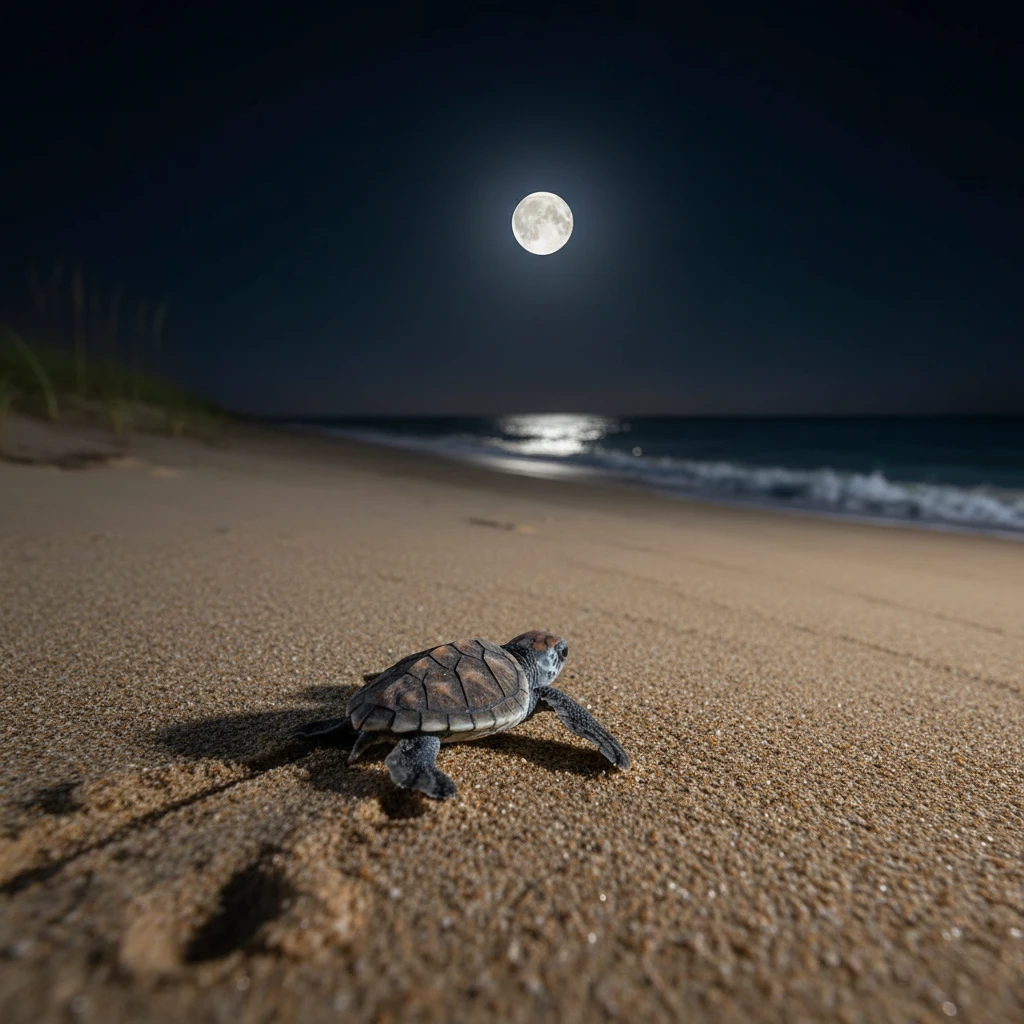
Roche Percée is not just a geological site; it is one of the most significant nesting grounds for the Green Sea Turtle (Chelonia mydas) and the Loggerhead Turtle (Caretta caretta) in the South Pacific. For New Zealand travelers accustomed to the marine life of the Hauraki Gulf, witnessing the nesting cycle in Bourail is a profound experience. The nesting season typically runs from November to February, with the peak activity occurring in December and January.
During these months, female turtles return to the very beach where they were born to lay their eggs. Under the cover of darkness, they haul their massive bodies up the sandy incline of Roche Percée beach, dig deep pits, and deposit approximately 100 eggs before returning to the ocean. The incubation period lasts about 60 days, meaning the ‘hatchling season’—when tiny turtles emerge and scurry toward the sea—usually peaks between January and March.
Conservation is taken very seriously in this region. The local association ‘Bwara Tortues Marines’ manages the site, ensuring that human interference is kept to a minimum. Visitors are encouraged to join guided night tours rather than exploring the beach alone with flashlights, as artificial light can disorient the turtles. For Kiwis, this commitment to conservation mirrors the efforts seen in New Zealand for species like the Kiwi or the Hector’s Dolphin, making it a relatable and educational stop on any itinerary.
How can visitors help protect the turtles?
Protection efforts include beach patrols and public education. Visitors should avoid using white lights on the beach at night; red-filtered torches are preferred as they are less disruptive to the turtles’ vision. Additionally, it is crucial to stay well back from a nesting female to avoid stressing her, which could cause her to abandon her nesting attempt. Keeping the beach free of plastic and debris is also vital, as turtles often mistake plastic bags for jellyfish, their primary food source.
What is the Three Bay Trail (Sentier des Trois Baies)?
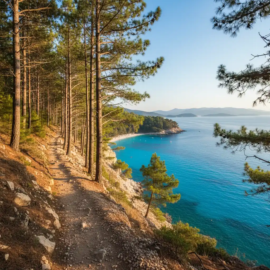
The Three Bay Trail (Sentier des Trois Baies) is arguably the most scenic coastal hike in New Caledonia. This 4-kilometer (round trip) trail connects three distinct and beautiful coastal areas: Roche Percée, Baie des Tortues (Turtle Bay), and Baie des Amoureux (Lovers’ Bay). The hike is relatively easy, making it accessible for families, yet it offers vistas that rival the best coastal walks in New Zealand, such as the Abel Tasman Track.
Starting at the Roche Percée parking area, the trail ascends the cliffside, providing an elevated view of the Bonhomme de Bourail. From this vantage point, hikers can see the turquoise lagoon stretching out toward the Great Barrier Reef. The path then winds through a forest of iconic Columnar Pines (Araucaria columnaris), which are endemic to New Caledonia. These tall, narrow trees create a prehistoric atmosphere, reminiscent of a scene from Jurassic Park.
As you descend into Baie des Tortues, you are greeted by a sheltered cove lined with ancient Cycas plants and Pandanus trees. This bay is often calmer than Roche Percée and is a perfect spot for a quiet rest. The final leg of the trail leads to Baie des Amoureux, a secluded, heart-shaped bay that feels worlds away from civilization. The entire walk takes about 1.5 to 2 hours at a leisurely pace, allowing plenty of time for photography and soaking in the sea breeze.
What should you bring on the Three Bay Trail?
While the trail is well-marked, the New Caledonian sun can be intense. Hikers should carry at least one liter of water, wear a wide-brimmed hat, and apply high-SPF sunscreen. Sturdy walking shoes are recommended, as some sections of the cliff path can be slippery after rain. For the best experience, start the hike early in the morning (around 7:00 AM) to avoid the midday heat and to catch the best light for photos of the Bonhomme.
Is surfing good at Roche Percee?
For New Zealand surfers used to the consistent swells of Raglan or the powerful breaks of Taranaki, Roche Percée offers a unique and thrilling experience. It is one of the few places in New Caledonia where you can find a reliable beach break. Unlike most of the surfing in the country, which requires a boat trip to the outer reef passes, Roche Percée allows surfers to paddle out directly from the shore.
The wave at Roche Percée is a hollow, powerful beach break that works best on a medium swell. It is known for its ‘punchy’ lefts and rights that break over a sandy bottom mixed with some rock. The presence of the Gouaro River mouth nearby helps to shape the sandbanks, creating conditions that can produce excellent barrels on the right day. However, it is important to note that the current can be strong, especially when the river is flowing heavily after rain.
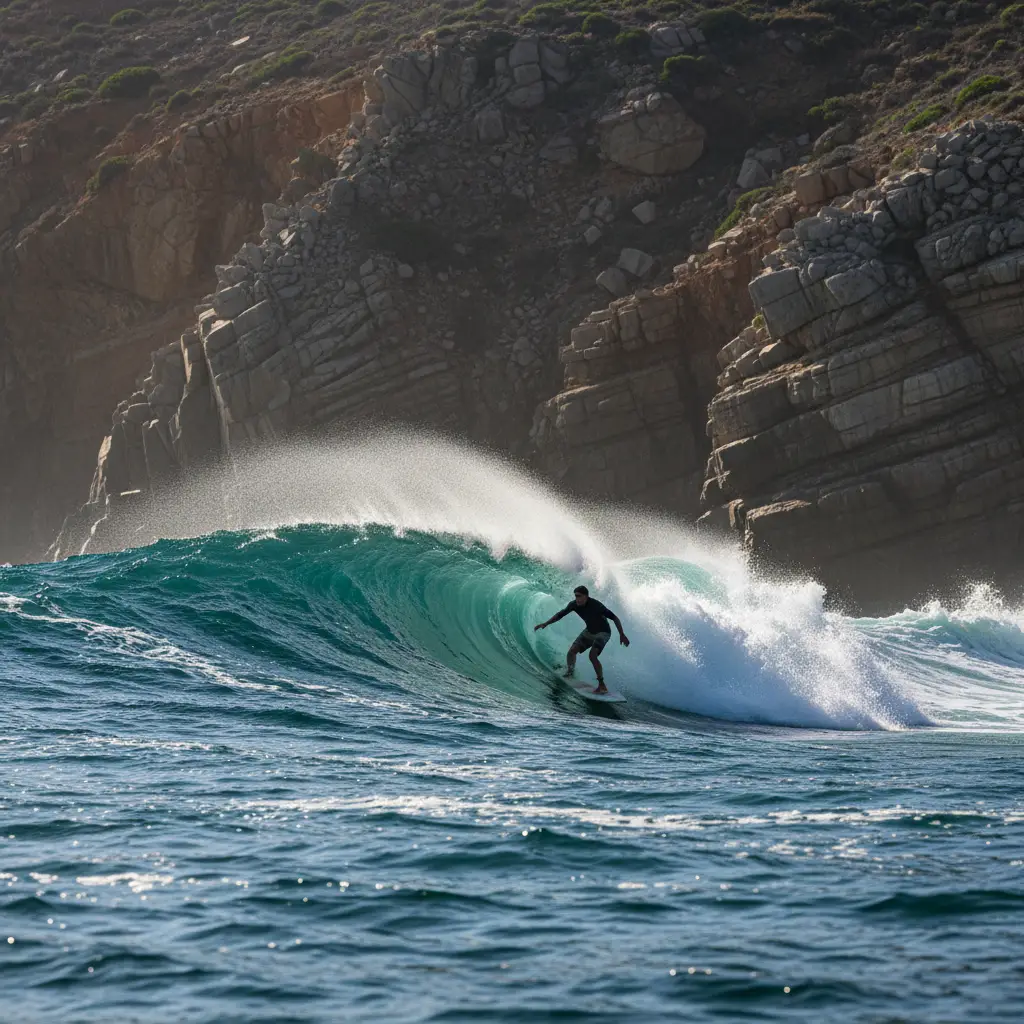
The surfing community in Bourail is welcoming but small. Because it is a beach break, it is more accessible for intermediate surfers than the heavy reef breaks found elsewhere. However, beginners should be cautious of the shorebreak, which can be quite heavy during high surf. For Kiwis looking to escape the cold winter waters of New Zealand, the 24-26°C water temperature at Roche Percée is a major drawcard, allowing for long sessions in just a rash vest or a thin spring suit.
Best conditions for surfing Bourail
The ideal conditions for Roche Percée are a South-West swell and an East or North-East wind (offshore). The tide also plays a significant role; many locals prefer the mid-to-high tide to prevent the waves from closing out too quickly on the shallow sandbars. If the beach break is too messy, seasoned surfers often head to the ‘Passe de Mara,’ a world-class reef break located a short boat ride from the Bourail boat ramp, which offers long, peeling walls and heavy tubes.
Travel Tips for New Zealanders Visiting Bourail
Bourail is located approximately 160 kilometers north of Noumea, the capital of New Caledonia. For New Zealanders, the journey begins with a short three-hour flight from Auckland to La Tontouta International Airport. From the airport, it is highly recommended to rent a car for the two-hour drive to Bourail.
The currency is the CFP Franc (XPF), and while French is the official language, many people in the tourism sector speak English. However, learning a few basic French phrases will go a long way in the rural ‘Broussard’ (cowboy) country of Bourail. The vibe here is relaxed and agricultural, often compared to the rural areas of the Waikato or Northland, but with a distinct French-Melanesian twist.
Accommodation options range from the luxurious Sheraton New Caledonia Deva Spa & Golf Resort to charming local ‘gîtes’ (homestays) and campsites near the beach. For a truly authentic experience, staying at a gîte allows you to taste local ‘Bourail beef’ and learn about the region’s history as a former penal colony and its current status as the heart of New Caledonia’s cattle ranching industry.
What is the best time of year to visit Bourail?
The best time to visit is during the shoulder seasons (April to June and September to November) for pleasant temperatures and lower humidity. If you want to see turtles, visit between December and February.
Is it safe to swim at Roche Percee?
Yes, swimming is generally safe in the designated areas. However, be aware of strong currents near the river mouth and high surf conditions. Always check local weather and surf reports.
How do I get from Noumea to Bourail?
The most common way is by rental car, which takes about 2 hours via the RT1 highway. There are also public buses (Raï) that run regularly between Noumea and Bourail.
Are there sharks at Roche Percee?
Like all tropical waters, sharks are present in the ocean. However, incidents are rare. It is advised to avoid swimming at dusk or dawn and near river mouths after heavy rain.
Do I need a visa to visit New Caledonia from New Zealand?
New Zealand citizens do not typically need a visa for short stays (up to 90 days) for tourism, but you must have a valid passport and a return ticket.
What should I wear for the Three Bay Trail?
Lightweight, breathable clothing, a hat, and comfortable walking shoes or sneakers are best. Don’t forget your swimwear for a dip in the bays!