A map of New Caledonia islands reveals a diverse archipelago in the Southwest Pacific, dominated by the massive Grande Terre mainland. Surrounding this central island are the Loyalty Islands (Lifou, Maré, Ouvéa) to the east and the Isle of Pines to the south, collectively forming a unique French-Melanesian territory situated approximately 1,200 kilometers east of Australia.
For New Zealand travelers, New Caledonia represents the closest taste of France, located just a three-hour flight north of Auckland. Understanding the geography of this archipelago is essential for planning an itinerary that goes beyond the capital city of Nouméa. From the UNESCO World Heritage-listed lagoon to the rugged peaks of the central mountain range, the topography of these islands dictates the type of adventure you will experience.
What does the Map of New Caledonia Islands look like?
When viewing a map of New Caledonia islands, you are looking at a fragment of the ancient supercontinent Gondwana. Unlike many of its volcanic Pacific neighbors, New Caledonia is a continental fragment, which accounts for its incredible biodiversity and distinct red soil. The archipelago is enclosed by the world’s largest enclosed lagoon and the second-largest double barrier reef, second only to Australia’s Great Barrier Reef.
The territory is administratively and geographically divided into three distinct provinces, but for the purpose of travel geography, we identify four key areas:
- Grande Terre: The cigar-shaped main island, 400km long and 50km wide.
- The Loyalty Islands: A line of three main islands (and smaller islets) sitting parallel to the East Coast.
- The Isle of Pines: A solitary, stunning island off the southern tip.
- The Belep Islands: A smaller, more remote group to the extreme north.

Overview of Grande Terre (The Mainland)
Grande Terre is the spine of the country. A central mountain range divides the island lengthwise, creating two distinct climatic and geographical zones that look entirely different on a topographic map.
The West Coast: The Wild West
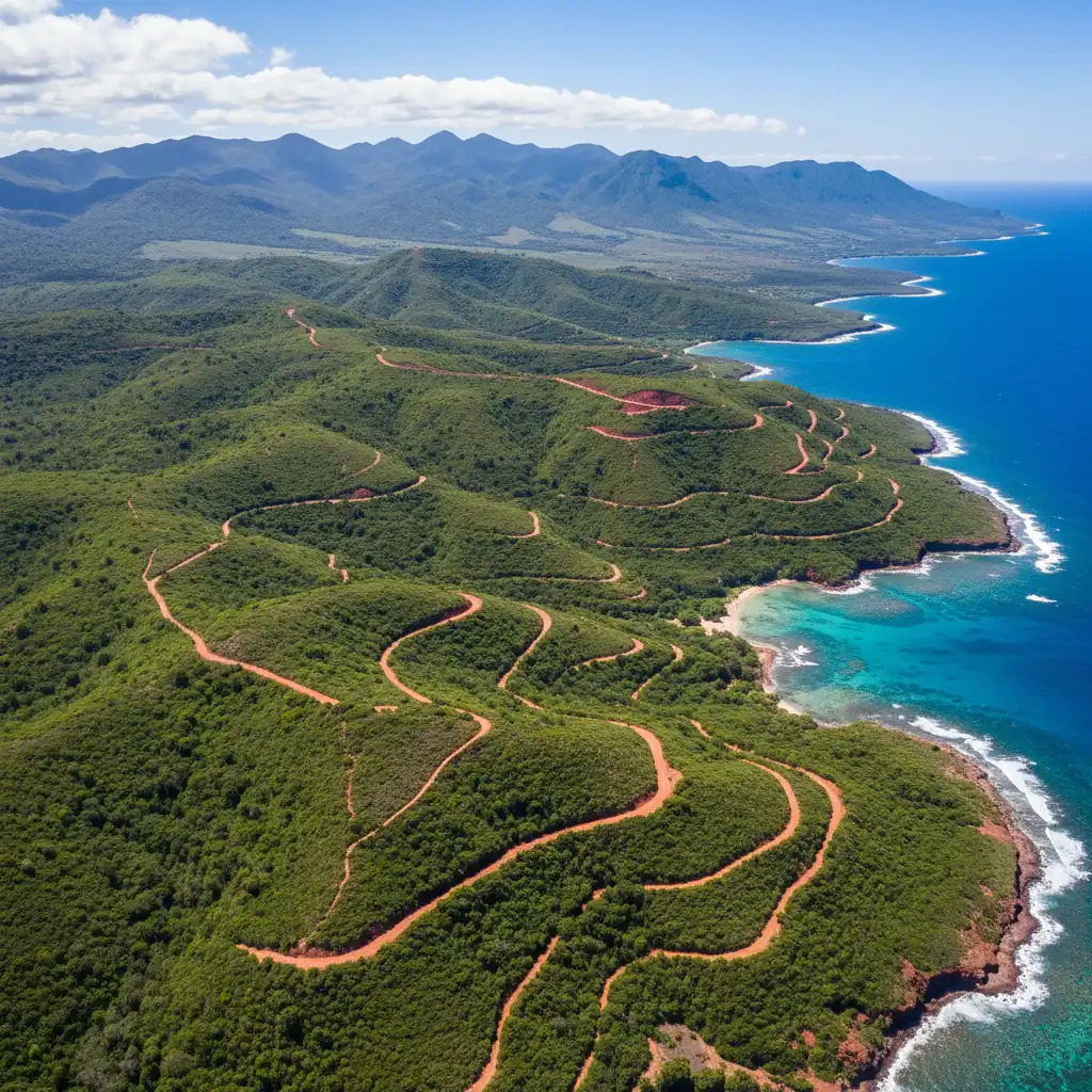
The West Coast, facing Australia, is characterized by dry savannahs, niaouli trees (similar to eucalyptus), and vast cattle stations. This is “Caloche” country, home to the local cowboys or stockmen. The geography here is flat and arid compared to the east. Key locations on the map include Bourail, home to the famous Roche Percée, and the heart-shaped mangrove formation in Voh, popularized by photographer Yann Arthus-Bertrand.
The East Coast: Tropical Lushness
Cross the central mountain chain (La Chaîne Centrale), and the map changes drastically. The East Coast is exposed to the trade winds, resulting in lush, dense tropical vegetation, waterfalls, and steep cliffs dropping into the sea. This area is the stronghold of Kanak culture. The coastal road offers spectacular views, particularly around Hienghène, where the famous black limestone “Brooding Hen” and “Sphinx” rock formations rise out of the bay.
The Great South (Grand Sud)
South of Nouméa, the map turns red. The soil here is rich in iron and nickel, creating a striking contrast against the green vegetation and the blue waters of the Lake Yaté. This region is a geological curiosity, hosting unique scrubland (maquis) and the drowned forest of the Blue River Park.
The Loyalty Islands Explained
Located approximately 100 kilometers east of Grande Terre, the Loyalty Islands (Les Loyauté) appear on the map as a linear chain. Unlike the mountainous mainland, these are raised coral atolls. They offer a classic Pacific island aesthetic but with distinct geological variations.
Lifou: The Immense Atoll
Lifou is the largest of the Loyalty Islands—in fact, it is larger than the island of Tahiti. Geographically, it is an immense fossilized coral plateau raised above sea level. The center of the island is flat and covered in dense bush, while the coastline is a mix of pristine white sand beaches (like Luengoni Beach) and dramatic coral cliffs (Jokin Cliffs). The map of Lifou is dotted with tribal villages, caves, and vanilla plantations.
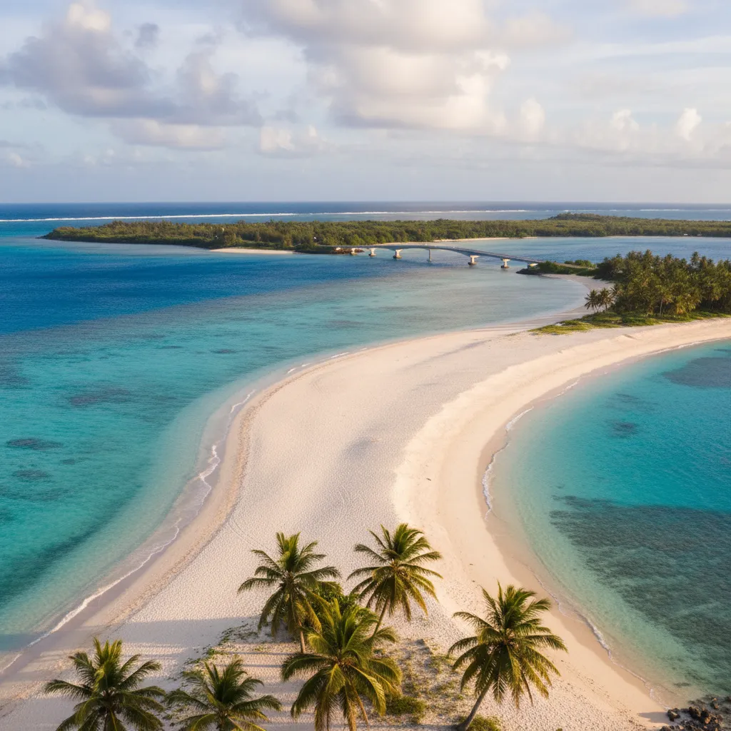
Ouvéa: The Closest Island to Paradise
Ouvéa is a true atoll, often described as the most beautiful beach in the Pacific. The map shows a crescent-shaped island with a 25-kilometer stretch of unbroken white sand along a brilliant turquoise lagoon. It is connected by a bridge to the smaller Mouli Island. The geography here is low-lying, making it vulnerable but stunningly beautiful. The “Pleiades” are a chain of islets extending from the main island, offering spectacular snorkeling.
Maré: The Wild Garden
Maré has the most rugged geography of the Loyalty group. It features high limestone cliffs, dark forests, and mysterious sinkholes (trou de Bone). The coastline is wilder, with basalt rocks mixing with coral. It is famous for its avocado festivals and the natural aquarium, a rock pool separated from the sea by a coral wall.
The Isle of Pines: Kunie
Lying south of Grande Terre, the Isle of Pines (Île des Pins) is often called the “Jewel of the Pacific.” On a map, it is distinct for the abundance of columnar Araucaria pine trees that line its bays, a geological anomaly for a tropical island.
The geography of the Isle of Pines is dominated by the peak N’Ga (262m), which offers a panoramic view of the island’s colors. The island is surrounded by a marine reserve. Key geographical features include:
- Oro Bay: Home to the Piscine Naturelle (Natural Pool), a natural aquarium protected from the ocean by a rock barrier.
- Kuto and Kanumera Bays: Twin bays separated by a narrow peninsula, offering some of the softest sand in the world.
- Upi Bay: A fjord-like bay scattered with coral rocks that seem to float on the water, reminiscent of Ha Long Bay but on a smaller, tropical scale.
Choosing the Right Island for your Holiday
For New Zealanders planning a trip, interpreting the map of New Caledonia islands is about matching geography to your travel style. The distances are deceptive; while flights are short, moving between islands requires planning.
For Families
Recommendation: Grande Terre (Nouméa) & Isle of Pines.
Nouméa offers the infrastructure, aquarium, and safe swimming at Baie des Citrons. A short 20-minute flight or the Betico ferry takes you to the Isle of Pines, which is compact, safe, and offers the magical experience of swimming with fish in shallow water at the Natural Pool.
For Couples & Honeymooners
Recommendation: Ouvéa.
The geography of Ouvéa screams romance. The isolation, the endless beach, and the luxury overwater or beachfront bungalows create a secluded atmosphere. It is less about activities and more about relaxation in a postcard setting.
For Adventurers
Recommendation: Grande Terre (North & East) or Maré.
Rent a car and drive the loop of Grande Terre. The changing topography from the dry west to the lush east provides a dynamic road trip. Alternatively, Maré offers hiking tracks that traverse rugged coral cliffs and hidden beaches, perfect for those who want to get off the beaten track.

Logistics: Navigating the Map
Understanding the map is one thing; traversing it is another. New Caledonia has a robust domestic transport network.
Air Travel
Air Calédonie operates domestic flights from Nouméa-Magenta airport (distinct from the international Tontouta airport). Flights to the Loyalty Islands and Isle of Pines take between 20 to 40 minutes. Because the islands are spread out, flying is the most time-efficient way to island-hop.
Sea Travel
The Betico 2 is a high-speed catamaran service connecting Nouméa to the Isle of Pines and the Loyalty Islands. The ferry to the Isle of Pines takes about 2.5 hours. Traveling to the Loyalty Islands by boat is longer (4+ hours) and can be rough depending on sea conditions, but it offers a scenic perspective of the archipelago’s vastness.
People Also Ask (PAA)
How many islands are in New Caledonia?
New Caledonia consists of dozens of islands. The main groupings are Grande Terre (the mainland), the Isle of Pines, and the four Loyalty Islands (Lifou, Maré, Ouvéa, and Tiga). Additionally, there are the Belep Islands to the north and numerous smaller uninhabited islets within the lagoon.
What is the best island to visit in New Caledonia?
The “best” island depends on your goal. The Isle of Pines is the most famous all-rounder for beauty and swimming. Ouvéa is best for beaches and relaxation. Lifou offers a mix of culture and nature. Grande Terre is best for road trips and diverse landscapes.
Is New Caledonia part of New Zealand?
No, New Caledonia is a special collectivity of France. While it is geographically close to New Zealand (part of the same submerged continent, Zealandia), it is politically and culturally French and Melanesian.
How long is the flight from New Zealand to New Caledonia?
The flight from Auckland (AKL) to Nouméa (NOU) takes approximately 3 hours. It is one of the shortest international flights available from New Zealand for a tropical holiday.
Do I need a visa for New Caledonia from NZ?
New Zealand passport holders do not need a visa for short tourist stays (up to 3 months) in New Caledonia. However, passports must be valid for at least three months beyond the date of departure.
What is the currency used in New Caledonia?
New Caledonia uses the Pacific Franc (CFP or XPF), which is pegged to the Euro. It is different from the currency used in France (Euro), but the fixed exchange rate provides stability.