Hiking trails in New Caledonia offer a diverse range of landscapes, from the iconic red soil of the Great South to the lush rainforests of the Central Chain. The premier experience is the GR1 NC, a long-distance trail traversing stunning lagoons, ancient forests, and unique biodiversity found nowhere else on Earth.
What is the GR1 NC (Great Walk)?
The GR1 NC, or Grande Randonnée 1, is New Caledonia’s flagship long-distance hiking trail. Stretching approximately 102 kilometers through the southern province of the main island, Grande Terre, it is often compared to New Zealand’s Great Walks but with a distinctively tropical and geological twist. This trail is not merely a path but a journey through the evolutionary history of the archipelago, showcasing the unique ‘maquis minier’ vegetation that has adapted to the mineral-rich, ultramafic soils.

The trail typically takes between five to seven days to complete, depending on the hiker’s pace and the number of stages combined. It is divided into seven distinct stages, each offering a different ecological perspective. Starting from the Prony area and ending near the Dumbea River, the GR1 takes adventurers through the heart of the Great South. Hikers can expect to encounter crystal-clear rivers, hidden waterfalls, and vast expanses of red earth that contrast sharply with the deep greens of the forest and the turquoise of the distant lagoon.
The Stages of the GR1
Each stage of the GR1 is meticulously marked with the classic red and white blazes familiar to European hikers. The terrain varies from flat, open plains to steep, technical climbs. One of the highlights is the passage through the ‘Plaine des Lacs,’ a plateau dotted with small lakes and unique wetlands. Accommodations along the route consist of designated campsites and rustic shelters (refuges), which must be booked in advance through the local tourism authorities. For New Zealanders used to the Department of Conservation (DOC) hut system, the experience is similar but requires a higher degree of self-sufficiency regarding water and food supplies.
How to Hike the Mont-Dore Summit?
The Mont-Dore summit hike is perhaps the most iconic day trek in New Caledonia. Located just a short drive from the capital, Nouméa, this 800-meter peak dominates the skyline and offers a challenging yet rewarding ascent. There are two primary routes to the summit: the ‘Sentier des Crêtes’ (Ridge Trail) and the ‘Sentier de la Corniche’ (Coastal/Forest Trail). Most seasoned hikers recommend ascending via the Ridge Trail to enjoy the panoramic views and descending via the Forest Trail to protect the knees from the steep, rocky descent.
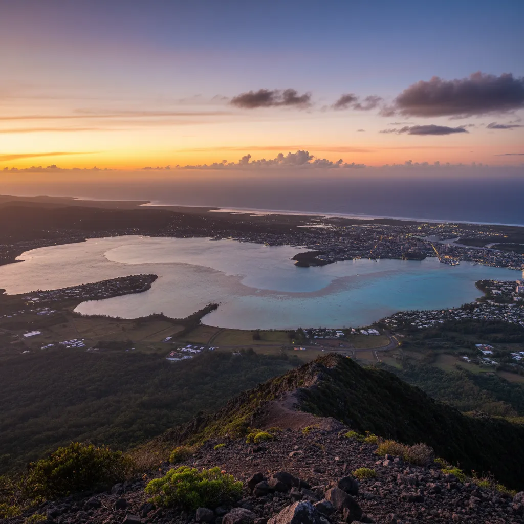
The Ridge Trail is famous for its ‘laterite’ soil—a deep, rusty red clay that can become incredibly slippery when wet and dusty when dry. As you climb, the vegetation thins out, revealing 360-degree views of the world’s largest lagoon, a UNESCO World Heritage site. From the summit, you can see the white sands of Amédée Island and the sprawling urban landscape of Nouméa. The hike typically takes between four to six hours round trip and requires a good level of physical fitness due to the sustained incline and exposure to the sun.
Choosing Your Route
The Ridge Trail (Red Route) is highly exposed. It is essential to start early—ideally at sunrise—to avoid the midday heat. The ‘Forest Route’ (Green Route) provides more shade but is longer and can be muddier. Many locals use Mont-Dore as a training ground for the GR1, as it mimics the technical footing and humidity levels found on the longer trek. Proper footwear with aggressive tread is non-negotiable here, as the red soil acts like ball bearings underfoot.
What are the Best Trails in Blue River Provincial Park?
Parc de la Rivière Bleue (Blue River Provincial Park) is a sanctuary for nature lovers and a cornerstone of New Caledonia’s conservation efforts. Covering over 9,000 hectares, the park is home to the ‘Grand Kaori,’ a thousand-year-old tree that stands as a testament to the island’s ancient botanical heritage. The park offers a network of trails suitable for all levels, from casual strolls to intensive day-long expeditions.

One of the most popular trails is the ‘Sentier de la Rivière Bleue,’ which follows the course of the river through the ‘Forêt Noyée’ (Drowned Forest). This hauntingly beautiful landscape features bleached white trunks of dead trees rising from the blue waters of the Yaté Dam reservoir. For those looking for a more strenuous challenge, the ‘Sentier des Houé’ provides a deep dive into the rainforest, where you might be lucky enough to spot the Cagou, New Caledonia’s national bird. This flightless, ghost-grey bird is endemic to the island and is known for its barking call.
The Grand Kaori and Beyond
No visit to the park is complete without seeing the Grand Kaori. The trail leading to it is relatively easy and accessible. Beyond the flora, the park is a hub for outdoor activities including mountain biking and kayaking. Many hikers choose to combine a morning trek with an afternoon paddle through the Drowned Forest. The park infrastructure is excellent, with well-maintained picnic areas and clear signage, making it an ideal destination for families traveling from New Zealand who want a mix of adventure and accessibility.
How to Stay Safe While Hiking in New Caledonia?
Safety on New Caledonia’s trails is primarily a matter of managing environmental factors: heat, hydration, and navigation. Unlike New Zealand’s alpine environments where cold and snow are the primary risks, New Caledonia’s tropical climate presents the danger of heat exhaustion and severe dehydration. The sun is exceptionally strong, and the lack of canopy cover on many trails, particularly in the South, means hikers are exposed for hours at a time.

Water management is critical. While there are rivers and streams, many are located in areas with heavy mineral concentrations or potential agricultural runoff. It is vital to carry a minimum of three liters of water per person for a day hike and to use a high-quality filtration system for multi-day treks like the GR1. Additionally, the red laterite soil is notoriously difficult to navigate after rain; it becomes a sticky, heavy mud that can double your travel time and increase the risk of slips and falls.
Supplies and Navigation
Always carry a physical map or a reliable offline GPS app like AllTrails or Gaia GPS, as mobile reception is non-existent once you enter the deep valleys of the interior. A basic first aid kit should include treatments for blisters, electrolyte replacement salts, and plenty of high-SPF sunscreen. It is also important to practice ‘La Coutume’ if you are hiking on tribal lands. This involves seeking permission from the local chief and often offering a small symbolic gift (like a piece of cloth or a small amount of money) as a gesture of respect for the land and its traditional owners.
How to Plan a Hiking Trip from New Zealand?
For New Zealanders, New Caledonia is a remarkably accessible destination, located just under three hours by air from Auckland. Air Calédonie International (Aircalin) and Air New Zealand operate regular flights to La Tontouta International Airport. The proximity makes it a viable option for a week-long hiking retreat or a longer exploration of the South Pacific.
The best time to visit for hiking is during the ‘cool season’ from May to September. During these months, temperatures range from 18°C to 24°C, making long-distance trekking much more comfortable than during the humid, cyclone-prone summer months (December to March). When packing, New Zealanders should bring their standard tramping gear but focus on lightweight, breathable fabrics. Heavy leather boots are often too hot; many hikers prefer trail running shoes or lightweight synthetic boots that dry quickly.
Why is New Caledonia’s Biodiversity Unique?
Hiking in New Caledonia is often described as walking through a living museum. The island is a ‘biodiversity hotspot’ with one of the highest rates of floral endemism in the world—about 76% of its 3,400 plant species are found nowhere else. This is largely due to the island’s long isolation after breaking away from the supercontinent Gondwana and its unusual soil chemistry.
As you traverse the GR1 or the trails in Blue River Park, you will notice the ‘maquis’—a shrubland that looks like it belongs on another planet. You will see carnivorous plants, ancient ferns, and species of Araucaria (pines) that have remained unchanged for millions of years. For a hiker from New Zealand, the similarities in some species (like the Kaori and the Nothofagus) are fascinating, providing a tangible link to our shared geological past while highlighting the distinct evolutionary path New Caledonia has taken.
People Also Ask
Is hiking in New Caledonia safe?
Yes, hiking is generally safe. There are no large predators or venomous land snakes. The primary risks are environmental, such as heat exhaustion, sun exposure, and slippery terrain. Always check weather forecasts and inform someone of your itinerary.
When is the best time to hike the GR1?
The best window is the cool season between May and September. The weather is drier and temperatures are significantly lower, reducing the risk of heat-related issues on the exposed ridges of the trail.
Do I need a guide for New Caledonia trails?
While many trails like Mont-Dore are well-marked and can be done solo, hiring a local guide for the GR1 or remote areas is recommended. Guides provide invaluable insight into the flora, fauna, and local Kanak culture.
What should I pack for hiking in the South Pacific?
Key items include lightweight breathable clothing, a wide-brimmed hat, high-SPF sunscreen, at least 3L of water capacity, a water filter, sturdy trail shoes, and offline maps. Don’t forget a lightweight rain jacket for tropical downpours.
How difficult is the Mont-Dore hike?
It is considered a moderate to difficult hike. The elevation gain is significant (800m) over a relatively short distance, and the terrain is rocky and exposed. A good level of fitness is required.
Are there venomous animals in New Caledonia?
New Caledonia has no venomous land snakes or large dangerous mammals. However, there are sea snakes (Tricot Rayé) which are highly venomous but docile and stay near the water. Standard precautions against mosquitoes and centipedes are advised.