A Grand Terre loop road trip is a comprehensive self-drive itinerary around New Caledonia’s main island, circling approximately 1,200 kilometers. This route connects the arid, cowboy-influenced West Coast with the lush, tropical Kanak villages of the East Coast, offering travelers a diverse experience of Melanesian culture, French cuisine, and spectacular ecological variety.
For New Zealanders looking for an overseas adventure that feels a world away yet sits only a three-hour flight from Auckland, New Caledonia offers a driving experience unlike any other in the Pacific. While many tourists stick to the beaches of Noumea or the Isle of Pines, the true soul of the country lies on the open roads of the “Grande Terre.” This guide provides a professional, deep-dive strategy for navigating the ultimate loop, tailored specifically for Kiwi drivers accustomed to the left side of the road.
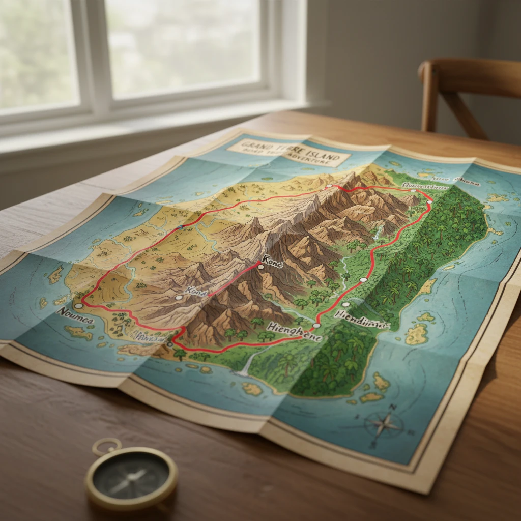
Map of the Grand Terre Loop: Understanding the Terrain
The Grande Terre is a long, narrow island, stretching roughly 400 kilometers from northwest to southeast. A central mountain range, the Chaine Centrale, acts as a spine dividing the island into two distinct climatic and cultural zones. Understanding this geography is paramount to planning a successful Grand Terre loop road trip.
Most travelers begin in the south at La Tontouta International Airport or the capital, Noumea. The classic loop involves driving up one coast, crossing the mountain range via one of the transverse roads (the most famous being the Koné-Tiwaka road), and descending the opposite coast. This ensures you experience the dramatic shift from the dry sclerophyll forests of the west to the humid rainforests of the east.
Driving on the Right: Essential Tips for Kiwi Drivers
For New Zealanders, the most immediate challenge of a New Caledonia road trip is the switch to the right-hand side of the road. While experienced travelers may adapt quickly, the rural nature of the Grande Terre requires specific vigilance.
What are the road rules in New Caledonia?
Traffic regulations align with French laws. You must drive on the right and overtake on the left. Speed limits are generally 110 km/h on major highways (like the RT1), 50 km/h in towns, and often 30 km/h near schools or tribal villages. Seatbelts are mandatory for all passengers, and the blood alcohol limit is strict (0.5g/l), though zero tolerance is recommended for tourists navigating unfamiliar terrain.
Understanding “Priorité à Droite”
A crucial rule that catches many Kiwis off guard is “priorité à droite” (priority to the right). Unless signed otherwise, vehicles entering a road from the right side have the right of way. This is less common on the main RT1 highway, which is a priority road, but in towns and rural intersections without stop signs or yield triangles, you must yield to traffic coming from your right. When in doubt, slow down and check.
Navigating Roundabouts
Roundabouts are ubiquitous in New Caledonia. Remember to look left and give way to traffic already on the roundabout. As you enter, drive counter-clockwise. This is the exact opposite of the New Zealand flow, so mental preparation at every intersection is vital to avoid instinctively looking the wrong way.
East Coast vs. West Coast Landscapes
The beauty of the Grand Terre loop road trip lies in the stark contrast between the two coasts. It is almost as if you are visiting two different countries within a single journey.
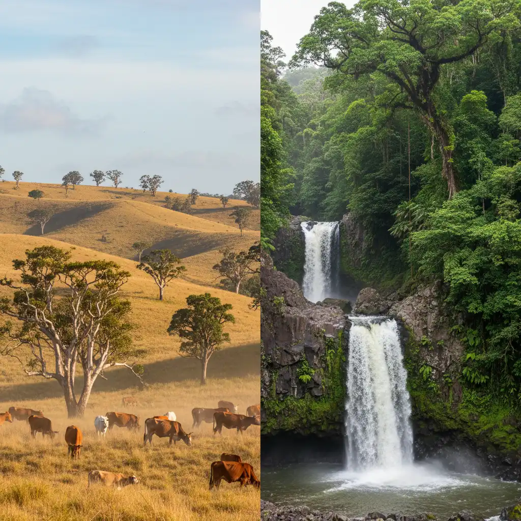
The West Coast: Le Far West
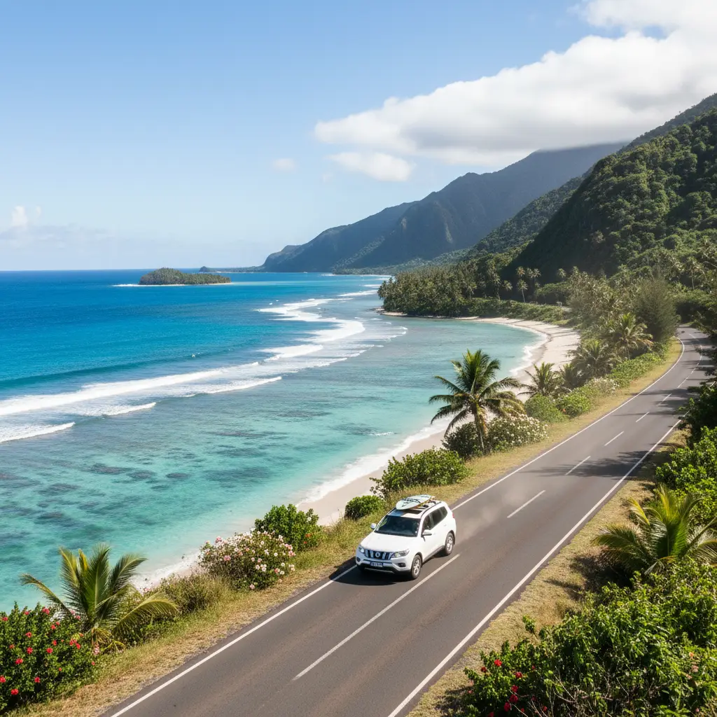
The West Coast is often referred to as “Le Far West” (The Wild West). This region is characterized by broad, grassy plains, savannahs dotted with paperbark (Niaouli) trees, and large cattle stations. Here, the culture is heavily influenced by the “Broussards” (bushmen/cowboys). The coastline features sweeping bays with white sand and calm lagoons protected by the barrier reef. It is drier, sunnier, and flatter, making for easy, high-speed driving on the RT1.
The East Coast: The Tropical Garden
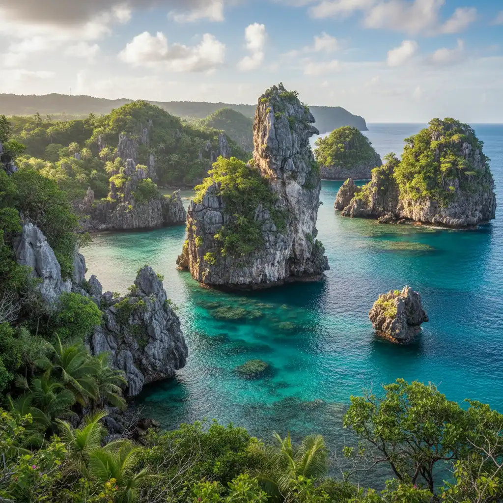
Crossing the central mountain range to the East Coast brings an immediate drop in temperature and a rise in humidity. The landscape transforms into a verdant jungle. Steep mountains plunge directly into the sea, coconut palms line the roads, and waterfalls cascade from high cliffs. The beaches here often feature black sand or dramatic limestone karst formations, such as the famous Lindéralique rocks in Hienghène. The East Coast is also the heartland of Kanak culture, where tribal villages (tribus) are more prominent, and life moves at a significantly slower pace.
Fuel Stops, Siestas, and Rural Logistics
Successful self-drive travel in New Caledonia requires distinct logistical planning that differs from a New Zealand road trip.
How to manage fuel in rural areas?
Fuel stations are plentiful in Noumea and major hubs like Bourail, Koné, and Poindimié. However, in the far north and along the remote stretches of the East Coast, stations can be 50 to 80 kilometers apart. Furthermore, many rural stations close early (around 5:00 PM or 6:00 PM) and may not open on Sundays. Always fill up when your tank reaches half-full. Note that most pumps are attended service; you do not pump your own gas unless it is an automated 24/7 card machine, which may not always accept foreign credit cards.
The Sacred Siesta and Opening Hours
Outside of Noumea, the French custom of the midday break is strictly observed. Between 11:30 AM and 2:00 PM, many shops, banks, post offices, and even gas stations may close. Restaurants usually stop serving lunch promptly at 1:30 PM. If you miss this window, you may be limited to snacks from a gas station until dinner service begins at 7:00 PM. Plan your driving schedule to ensure you have secured food or are seated at a restaurant by noon.
Connectivity and Navigation
While mobile coverage (4G) is generally good along the main RT1, dead zones exist in the mountainous passes and the far north. It is highly recommended to download offline maps (Google Maps or Maps.me) before leaving Wi-Fi zones. Do not rely solely on streaming data for navigation.
The Ultimate 10-Day Self-Drive Itinerary
This itinerary is designed to maximize scenic value while maintaining a manageable driving pace. It follows a counter-clockwise loop, starting up the West Coast and returning via the East Coast.
Days 1-2: The West Coast & Bourail
Route: Noumea to Bourail (approx. 165 km)
Depart Noumea on the RT1. Your first major stop is La Foa, a historic settlement known for its colonial architecture. Continue to Bourail, the capital of the rural west. Spend your time exploring the Domaine de Deva, a massive nature reserve offering hiking and biking trails.
Must-Do: Visit La Roche Percée (The Pierced Rock) and the Bonhomme de Bourail, a striking rock formation shaped like a man’s head. The nearby Poé Beach is a UNESCO World Heritage site perfect for kayaking and glass-bottom boat tours.
Days 3-4: The Far North & Poum
Route: Bourail to Poum (approx. 240 km)
Drive north through Koné (the gateway to the north) and Koumac. As you approach the northern tip of the island, civilization thins out, and the earth turns a vibrant red. This is the “Grand Nord.” Stay in a gîte (guesthouse) in Poingam or Poum.
Must-Do: Visit the Boat Pass (Relais de Poingam) at the very end of the road. Walk the salt flats and enjoy a seafood dinner featuring locally caught crab. The isolation here is profound and beautiful.
Days 5-7: The Majestic East Coast & Hienghène
Route: Poum to Hienghène via the Col d’Amos (approx. 160 km)
Cross from West to East. The drive over the Col d’Amos offers panoramic views of the lagoon. Descend into the lush vegetation of the East Coast. Your destination is Hienghène, arguably the most visually stunning location in New Caledonia.
Must-Do: Take a boat trip to see the Sphinx and the Brooding Hen (Poule Couveuse) rock formations from the water. Visit the Belvédère viewpoint for the classic postcard shot. Drive north of Hienghène to experience the Ouaïème Ferry (Bac de la Ouaïème), the last remaining river ferry in the country, which operates 24/7 and is free of charge.
Days 8-9: Poindimié and the Cross-Island Road
Route: Hienghène to Sarraméa via Koné-Tiwaka (approx. 200 km)
Drive south to Poindimié, a fantastic spot for scuba diving and snorkeling. Afterward, take the famous Koné-Tiwaka (Rpn 2) road back toward the west. This road is an engineering marvel, offering smooth driving through spectacular mountain scenery. Instead of returning all the way to the coast, turn off toward Sarraméa, a cool, mountainous enclave nestled in the forest.
Must-Do: Hike the Plateau de Dogny in Sarraméa for incredible views. Visit the Parc des Grandes Fougères (Park of the Great Ferns) to see prehistoric tree ferns and endemic birdlife, including the Kagu.
Day 10: Return to Noumea
Route: Sarraméa to Noumea (approx. 120 km)
Enjoy a leisurely morning in the mountains before rejoining the RT1 for the final drive south to Noumea. If time permits, stop at the Boulouparis distillery to sample local Niaouli essence products.
People Also Ask
Do I need an International Driving Permit for New Caledonia?
For New Zealand driver’s license holders, an International Driving Permit (IDP) is generally not required if your license is in English. However, carrying an IDP is always a safe precaution for insurance purposes and interactions with local police who may not be fluent in English.
Is it safe to drive in New Caledonia at night?
Driving at night is generally discouraged outside of Noumea. Rural roads lack street lighting, and hazards such as stray cattle, horses, and pedestrians walking on the shoulder are common and difficult to see in the dark. Plan to reach your accommodation before sunset.
What type of car should I rent for the loop?
While the main roads (RT1 and Rpn 2) are sealed and in good condition, a compact SUV or crossover is highly recommended. The extra ground clearance is beneficial for accessing guesthouses with gravel driveways, navigating potholes in the north, and providing better visibility.
How much does fuel cost in New Caledonia?
Fuel prices in New Caledonia are government-regulated, meaning the price is the same at every service station across the island. It is generally comparable to or slightly higher than New Zealand prices. Budget accordingly for approximately 150-180 XPF per liter (prices fluctuate).
Can I camp around Grand Terre?
Yes, camping is a popular option. There are designated campsites (campings) often attached to gîtes or tribal accommodations. Wild camping is not recommended; you must always ask permission from the local tribe (La Coutume) before staying on customary land.
What is “La Coutume” and how does it affect my trip?
“Faire la coutume” is a gesture of respect when entering tribal lands or Kanak villages. It involves presenting a small gift (typically a piece of fabric called a “manou” and a 500 or 1000 XPF note) to the chief or host. While not required for staying in commercial hotels, it is essential if you are visiting remote villages or asking to access specific sites on tribal land.