Pic N’Ga hike difficulty is classified as moderate, typically taking 1.5 to 2 hours to complete. The 262-meter climb features steep, rocky limestone sections and slippery red clay. While manageable for most fitness levels, the exposed trail requires sturdy hiking shoes, sun protection, and plenty of water for the humid conditions.
How hard is the Pic N’Ga hike? Trail Difficulty and Duration
For New Zealanders accustomed to the rugged terrain of the Southern Alps or the volcanic tracks of the North Island, the Pic N’Ga hike difficulty will feel like a manageable but rewarding challenge. Standing at 262 meters, Pic N’Ga is the highest point on the Isle of Pines (Île des Pins) in New Caledonia. While the elevation might seem modest compared to Mount Taranaki or the Tongariro Crossing, the tropical climate and specific geological features of the island introduce unique factors that hikers must consider.
The hike is generally rated as moderate. The average hiker can expect to reach the summit in approximately 45 to 60 minutes, with a total round-trip time of about 1.5 to 2 hours. However, this timeframe can vary significantly based on your fitness level and how often you stop to admire the increasingly spectacular views of the lagoon. The ascent is relatively short but consistently steep, with very few flat sections once you leave the base. For those traveling from New Zealand, think of it as a slightly more humid and rocky version of climbing Mount Maunganui, but with a significantly sharper terrain underfoot.
Physical Fitness and Stamina
You do not need to be an elite athlete to conquer Pic N’Ga, but a basic level of cardiovascular fitness is required. The trail involves a steady incline that will get your heart rate up quickly. Because the path is largely exposed to the sun, the heat can sap your energy faster than a temperate NZ forest trek. If you are comfortable walking for two hours on uneven ground, you will find this hike well within your capabilities. Families with children often complete the trek, though younger children may need assistance on the larger rock steps near the summit.
What is the terrain like on Pic N’Ga?
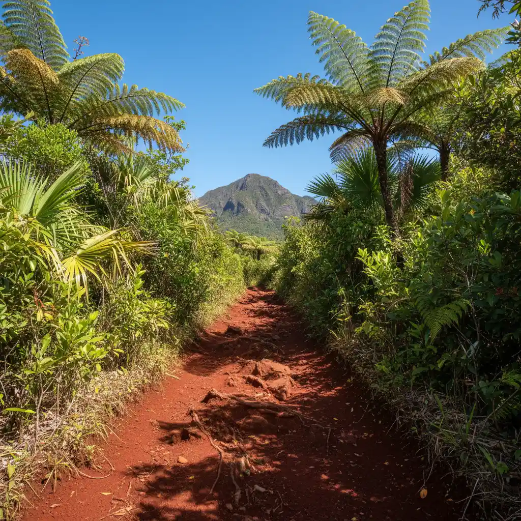
The Pic N’Ga hike difficulty is largely defined by its footing. The trail transitions through several distinct geological zones, each offering its own set of challenges. At the base, the path is wide and composed of the iconic New Caledonian red clay, known as laterite. This soil is rich in iron and can become incredibly slick after even a light tropical shower. For Kiwis used to muddy bush walks, this is a different kind of slippery—more like walking on wet soap than soft mud.
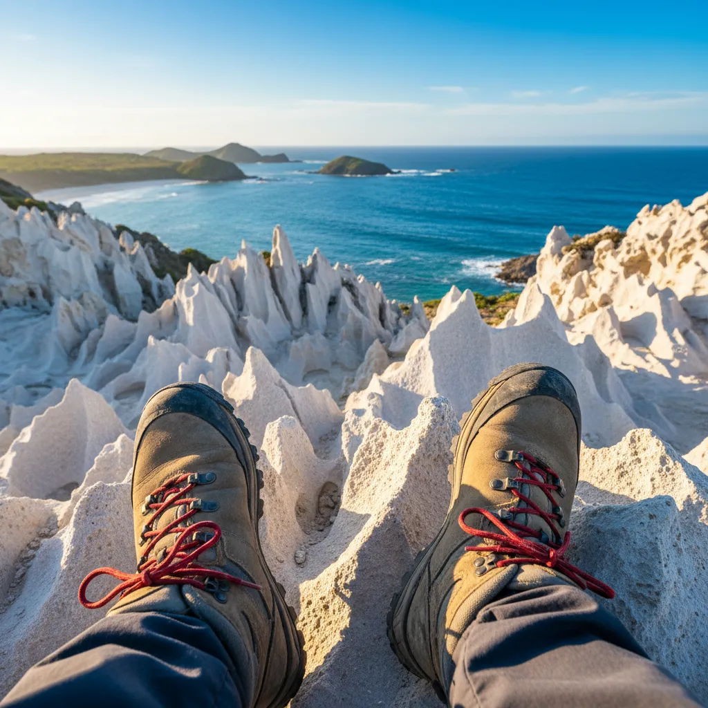
As you ascend, the clay gives way to sharp limestone outcrops. The Isle of Pines is essentially a massive coral reef that has been uplifted over millennia, and the rock at the top reflects this maritime history. The limestone is jagged and abrasive; a slip here can easily result in scrapes or cuts. The path also features loose scree in certain sections, requiring careful foot placement on the descent to avoid rolling an ankle. Unlike many groomed tracks in New Zealand’s Great Walks, the Pic N’Ga trail is raw and natural, with minimal man-made stairs or railings.
Is the trail well-marked?
The trail is relatively easy to follow, but it is not signposted with the frequency of a DOC track. There are occasional splashes of paint on rocks to guide the way, and the path itself is well-trodden. However, in the lower sections where several goat tracks might diverge, it is important to stay on the most worn path. If you find yourself pushing through thick scrub, you have likely veered off course. The general rule is to keep heading upward; since the peak is the only high point in the immediate vicinity, it is difficult to get truly lost.
What to pack: Water, Shoes, and Sun Protection
Preparation is key to mitigating the Pic N’Ga hike difficulty. Because New Caledonia is closer to the equator than New Zealand, the sun intensity is significantly higher, and the humidity can be oppressive, even in the ‘cool’ season (May to October). Packing correctly will transform a potentially grueling climb into an enjoyable excursion.
The Right Footwear
Do not attempt this hike in flip-flops (jandals). While you might see some locals doing it, the sharp limestone and slippery clay make sturdy footwear essential. A pair of trail running shoes or lightweight hiking boots with good grip is ideal. If you are coming from NZ, your standard tramping boots might feel a bit heavy and hot, but they will provide the necessary ankle support and protection against the jagged rocks. Ensure your shoes are broken in, as the constant incline can cause friction and blisters in new footwear.
Hydration is Critical
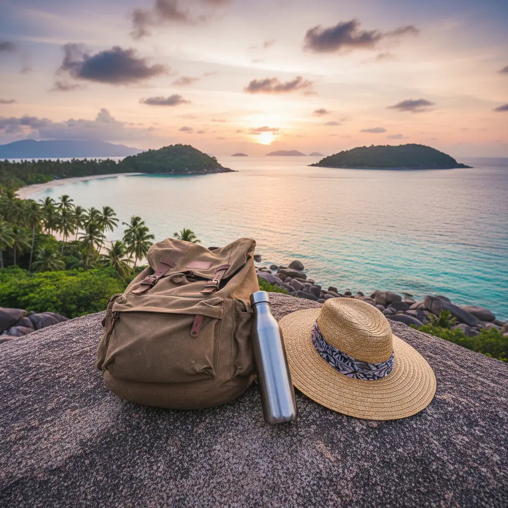
There are no water sources on the trail. You should carry at least 1.5 liters of water per person. The humidity in New Caledonia causes high sweat rates, and dehydration can set in quickly during the steep ascent. Consider adding electrolytes to your water to maintain your mineral balance. A light snack, such as a muesli bar or some local fruit, is a good idea to enjoy at the summit while you soak in the views.
Sun and Skin Protection
The trail offers almost zero shade. A wide-brimmed hat, high-SPF sunscreen, and polarized sunglasses are non-negotiable. Many hikers also find a lightweight, long-sleeved ‘sun shirt’ helpful to protect their skin without overheating. Additionally, the red clay is notorious for staining clothes permanently. Avoid wearing your favorite expensive white gear; opt for darker colors or older hiking clothes that you don’t mind getting a bit of ‘Isle of Pines’ character on.
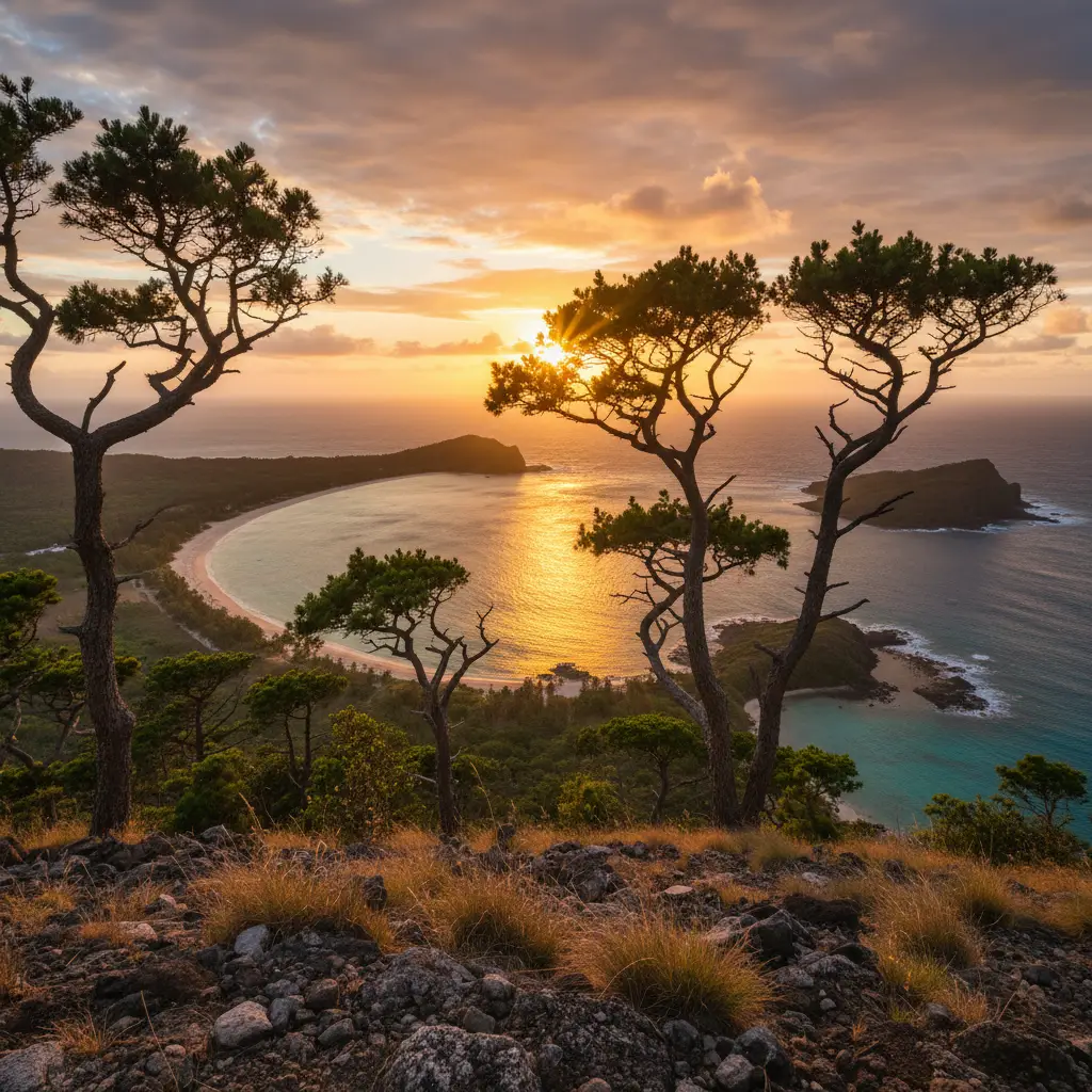
The Reward: Panoramic Views from the Summit
The primary reason people tackle the Pic N’Ga hike difficulty is the unparalleled 360-degree view from the top. Once you reach the summit, marked by a collection of wooden crosses and a small orientation table, the entire geography of the Isle of Pines unfolds beneath you. It is arguably the best vantage point in all of New Caledonia.
To the north, you can see the shimmering turquoise waters of Oro Bay and the famous natural swimming pool (Piscine Naturelle). To the west, the twin bays of Kuto and Kanumera are visible, separated by a narrow volcanic isthmus. The contrast between the deep blue of the open ocean beyond the reef and the pale, milky turquoise of the lagoons is staggering. On a clear day, you can see the distant reefs that protect the island, creating the calm waters for which the Isle of Pines is famous. For photographers, the summit provides a perfect opportunity to capture the island’s signature columnar pines (Araucaria columnaris) which give the island its name, standing like sentinels along the white sand coastlines.
When to Hike: Sunrise vs. Sunset
Timing your hike can drastically change your experience of the Pic N’Ga hike difficulty and the visual payoff. Both sunrise and sunset offer unique advantages, but they also require different levels of preparation.
The Case for Sunrise
Hiking at dawn is the best way to beat the tropical heat. Starting your ascent around 5:00 AM (depending on the season) allows you to climb in the cool, pre-dawn air. Watching the sun rise over the Pacific Ocean and illuminate the lagoons is a spiritual experience. The light is soft and perfect for photography, and you will likely have the summit to yourself before the day-trippers arrive from the main island. However, you will need a high-quality headlamp for the ascent, as the red clay sections can be tricky to navigate in the dark.
The Case for Sunset
Sunset hikes offer a spectacular display of colors as the sun dips behind the horizon near Kuto Bay. The sky often turns shades of burnt orange, pink, and purple, reflecting off the calm waters below. The descent, however, can be more dangerous. The light fades quickly in the tropics, and navigating the sharp limestone rocks and slippery clay during twilight requires extreme caution. If you choose a sunset hike, ensure you leave the summit immediately after the sun disappears and have a reliable light source for the walk back down.
Safety, Local Etiquette, and Practical Information
While the Pic N’Ga hike difficulty is manageable, safety should always be a priority. Always inform someone at your hotel or guesthouse of your plans and expected return time. There is generally mobile reception on the peak, but it can be spotty on the lower slopes. If you are hiking alone, be extra cautious on the rocky sections.
Respecting the Land (Kanak Culture)
The Isle of Pines is home to the indigenous Kanak people, and the land is deeply significant to them. While Pic N’Ga is a popular tourist trail, it is important to treat the environment with respect. Stay on the marked paths to avoid erosion, and never leave any litter behind. If you encounter locals on the trail, a friendly “Bonjour” goes a long way. Remember that you are a guest on their ancestral land.
How to get to the trailhead
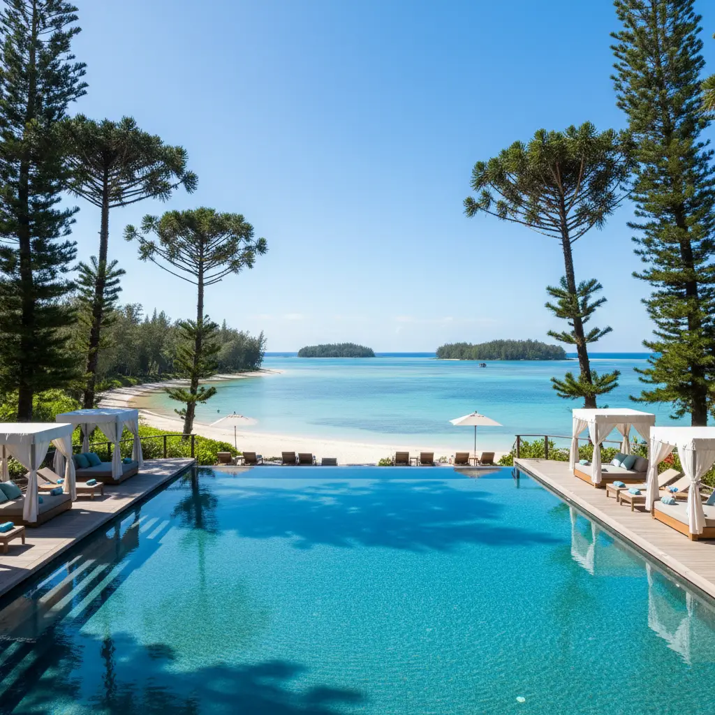
The trailhead for Pic N’Ga is located near the village of Kuto. If you are staying at the Oure Tera Beach Resort or Hotel Kou-Bugny, you can easily walk to the start of the track. Look for the small sign off the main road that leads toward the interior of the island. For those staying further away, such as at Oro Bay, a shuttle or a rental bike is the most common way to reach the base. Most New Zealand travelers arrive via the Betico 2 ferry from Noumea or a short domestic flight with Air Calédonie; both options provide easy access to the Kuto area.
Frequently Asked Questions
Is the Pic N’Ga hike suitable for children?
Yes, children with a reasonable level of energy can complete the hike. However, parents should be mindful of the sharp rocks and steep sections. It is recommended for children aged 7 and up who have some experience walking on uneven terrain.
Do I need a guide to hike Pic N’Ga?
A guide is not strictly necessary as the trail is well-defined. However, a local guide can provide fascinating insights into the island’s flora, fauna, and history, which can enrich the experience significantly.
What is the best time of year to hike?
The best time is during the cooler, drier months from May to October. During the wet season (November to April), the trail can become very slippery and the humidity can make the climb much more strenuous.
Are there any entry fees for the trail?
As of current knowledge, there is no official entry fee to hike Pic N’Ga. It is a natural attraction open to the public, though it is always wise to check with your local accommodation for any recent changes in land access rules.
How long does the entire trip take?
From Kuto Bay, allow about 2.5 to 3 hours in total. This includes the walk to the trailhead, the 1-hour ascent, time at the summit for photos, and the 45-minute descent.
What should I do if it starts raining during the hike?
If heavy rain begins, exercise extreme caution. The red clay sections become very slippery. It is often safer to descend slowly and carefully immediately, or find a stable rocky area to wait out the shower if it appears brief.